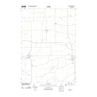
2010 Map of Randolph
USGS Topo · Published 2010About this map
Cambria and Randolph anchor this agricultural landscape in Columbia County, where a grid of rural routes like County Hwy-P and County Hwy-Rd E connects small dairy-country settlements. The map highlights a strong Welsh and Frisian heritage through its place names and burial grounds, including the Blaen Y Cae Cemetery in the northeast and the Randolph Center Cemetery just outside Friesland. In Cambria, the Cambria WP53 Dam controls the waters of Tarrant Lake 17, while the surrounding terrain is drained by the meandering North Branch Duck Creek and Middle Branch Duck Creek. This 2010 survey captures the established footprint of these communities, from the Randolph Post Office to the outlier village of East Friesland, documenting the persistence of small-town infrastructure and family-named landmarks such as Schmidt Rd and Posthuma Rd across the Wisconsin prairie.
Find a feature on this map
48 named features on this map. Tap any name to fly to it.
Don’t see what you’re looking for? This feature index may not catch every label — zoom into the map to look around manually.
Map Details
Editions of this 2010 Randolph Map
This is the sole edition of this map. No revisions or reprints were ever made.
Other maps of this area

1955 · Randolph
USGS Topo · 1:62,500

1955 · Columbus
USGS Topo · 1:62,500

1955 · Beaver Dam
USGS Topo · 1:62,500

1955 · Fox Lake
USGS Topo · 1:62,500

1957 · Madison
USGS Topo · 1:250,000

1960 · Madison
USGS Topo · 1:250,000

1980 · Fond Du Lac
USGS Topo · 1:100,000

1980 · Lost Lake
USGS Topo · 1:24,000
1980 · Manchester
USGS Topo · 1:24,000
1980 · Rio
USGS Topo · 1:24,000