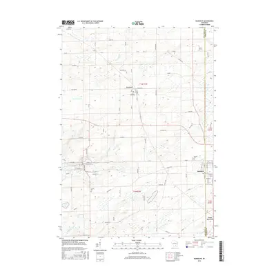
2016 Map of Randolph
USGS Topo · Published 2016About this map
The agrarian landscape of the Columbia and Dodge County line is defined by a dense network of country roads and the headwaters of several regional waterways. In the north, the village of Friesland serves as a local hub, situated near the Randolph Center Cem and the upper reaches of the Fox River. The topography is marked by glacial features and drainage patterns, including Sand Spring Cr and the various branches of Duck Creek. To the southeast, the town of Randolph straddles the county boundary, with its residential grid extending toward South Randolph. Genealogists and local historians will find several burial sites well-preserved in this modern survey, from the Blaen Y Cae Cem in the northeast to the Cambria Cem on the western edge of the quadrangle. Significant water features like Tarrant Lake and North Br Duck Cr illustrate the drainage of this productive Wisconsin farmland.
Find a feature on this map
73 named features on this map. Tap any name to fly to it.
Don’t see what you’re looking for? This feature index may not catch every label — zoom into the map to look around manually.
Map Details
Editions of this 2016 Randolph Map
This is the sole edition of this map. No revisions or reprints were ever made.
Other maps of this area

1955 · Randolph
USGS Topo · 1:62,500

1955 · Columbus
USGS Topo · 1:62,500

1955 · Beaver Dam
USGS Topo · 1:62,500

1955 · Fox Lake
USGS Topo · 1:62,500

1957 · Madison
USGS Topo · 1:250,000

1960 · Madison
USGS Topo · 1:250,000

1980 · Fond Du Lac
USGS Topo · 1:100,000

1980 · Lost Lake
USGS Topo · 1:24,000
1980 · Manchester
USGS Topo · 1:24,000
1980 · Rio
USGS Topo · 1:24,000