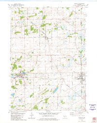
1980 Map of Randolph
USGS Topo · Published 1981About this map
Agricultural life and rail transport define this 1980 survey of the borderlands between Columbia and Dodge Counties. Two major rail corridors, the Chicago and North Western and the Chicago Milwaukee St Paul and Pacific, intersect the landscape, linking the village of Randolph with neighboring Cambria and Friesland. These tracks follow the natural contours of the land, carving through a region marked by numerous wetlands and the headwaters of the Fox River and Duck Creek.
Find a feature on this map
38 named features on this map. Tap any name to fly to it.
Don’t see what you’re looking for? This feature index may not catch every label — zoom into the map to look around manually.
Map Details
Editions of this 1980 Randolph Map
This is the sole edition of this map. No revisions or reprints were ever made.
Other maps of this area

1955 · Randolph
USGS Topo · 1:62,500

1955 · Columbus
USGS Topo · 1:62,500

1955 · Beaver Dam
USGS Topo · 1:62,500

1955 · Fox Lake
USGS Topo · 1:62,500

1957 · Madison
USGS Topo · 1:250,000

1960 · Madison
USGS Topo · 1:250,000

1980 · Fond Du Lac
USGS Topo · 1:100,000

1980 · Lost Lake
USGS Topo · 1:24,000
1980 · Manchester
USGS Topo · 1:24,000
1980 · Rio
USGS Topo · 1:24,000