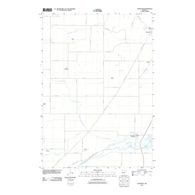
2010 Map of Randolph
USGS Topo · Published 2010About this map
The Cannon River valley in Dakota County is the primary geographic feature of this 2010 topographic study, which highlights a landscape of orderly agricultural grid systems and quiet rural hamlets. The village of Randolph sits at the confluence of several watercourses, including the meandering Chub Creek and its north branch, serving as a local hub with its Randolph Post Office. To the north, the small settlement of Hampton is anchored by Saint Mathias Cemetery, while the western edge of the quadrangle is marked by Castle Rock.
Find a feature on this map
59 named features on this map. Tap any name to fly to it.
Don’t see what you’re looking for? This feature index may not catch every label — zoom into the map to look around manually.
Map Details
Editions of this 2010 Randolph Map
This is the sole edition of this map. No revisions or reprints were ever made.
Other maps of this area

1953 · Saint Paul
USGS Topo · 1:250,000

1957 · Farmington
USGS Topo · 1:62,500

1957 · Hastings
USGS Topo · 1:62,500

1959 · Saint Paul
USGS Topo · 1:250,000

1960 · Northfield
USGS Topo · 1:24,000

1960 · Dennison
USGS Topo · 1:24,000

1968 · Sogn
USGS Topo · 1:24,000
1974 · Coates
USGS Topo · 1:24,000
1974 · Randolph
USGS Topo · 1:24,000
1974 · Castle Rock
USGS Topo · 1:24,000