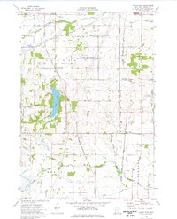
1974 Map of Castle Rock
USGS Topo · Published 1976About this map
Eureka Center and the village of Castle Rock anchor this mid-1970s landscape in southern Dakota County, where agricultural patterns meet growing industrial and aviation infrastructure. The northern edge features the Airlake Industrial Airport, while the rest of the quadrangle is defined by a dense grid of rural roads like Pilot Knob Road and Danbury Avenue. Water features are central to the terrain, notably Chub Lake and the meandering Vermillion River.
Find a feature on this map
56 named features on this map. Tap any name to fly to it.
Don’t see what you’re looking for? This feature index may not catch every label — zoom into the map to look around manually.
Map Details
Editions of this 1974 Castle Rock Map
This is the sole edition of this map. No revisions or reprints were ever made.
Other maps of this area

1953 · Saint Paul
USGS Topo · 1:250,000

1957 · Farmington
USGS Topo · 1:62,500

1957 · Prior Lake
USGS Topo · 1:62,500

1959 · Saint Paul
USGS Topo · 1:250,000

1960 · Northfield
USGS Topo · 1:24,000

1960 · Dennison
USGS Topo · 1:24,000

1960 · Little Chicago
USGS Topo · 1:24,000
1974 · Coates
USGS Topo · 1:24,000
1974 · New Market
USGS Topo · 1:24,000
1974 · Randolph
USGS Topo · 1:24,000