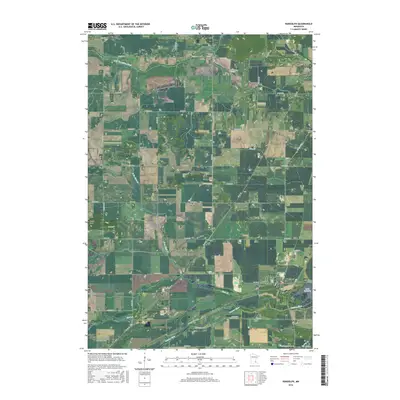
2016 Map of Randolph
USGS Topo · Published 2016About this map
The Cannon River and Lake Byllesby anchor the southern reaches of this landscape where the borders of Dakota Co and Goodhue Co meet. The terrain is defined by a dense network of watercourses, including Chub Cr, the S Br Vermillion River, and Pine Cr, which have shaped the agricultural development of the region. Small settlements such as Randolph, Hampton, and Castle Rock are dispersed across a grid of section roads and county highways like Co Rd 47 and Co Rd 80. Genealogists will find a significant concentration of local burial sites, from Saint Mathias Cem in the northeast to the more isolated Kibbe Cem and Redrose Cem further south. These landmarks, along with aviation sites like Lucht Field, illustrate the rural social structure and transportation evolution of southern Minnesota.
Find a feature on this map
74 named features on this map. Tap any name to fly to it.
Don’t see what you’re looking for? This feature index may not catch every label — zoom into the map to look around manually.
Map Details
Editions of this 2016 Randolph Map
This is the sole edition of this map. No revisions or reprints were ever made.
Other maps of this area

1953 · Saint Paul
USGS Topo · 1:250,000

1957 · Farmington
USGS Topo · 1:62,500

1957 · Hastings
USGS Topo · 1:62,500

1959 · Saint Paul
USGS Topo · 1:250,000

1960 · Northfield
USGS Topo · 1:24,000

1960 · Dennison
USGS Topo · 1:24,000

1968 · Sogn
USGS Topo · 1:24,000
1974 · Coates
USGS Topo · 1:24,000
1974 · Randolph
USGS Topo · 1:24,000
1974 · Castle Rock
USGS Topo · 1:24,000