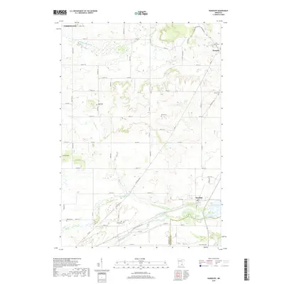
2019 Map of Randolph
USGS Topo · Published 2019About this map
Lake Byllesby and the winding Cannon River anchor the southern landscape of this Dakota County region, where the terrain transitions from agricultural fields to complex river valleys. The area is defined by a dense network of watercourses, including Chub Creek and the South Branch Vermillion River, which have historically shaped the settlement patterns of towns like Randolph and Hampton. For genealogists and local historians, the map identifies several distinct burial grounds that mark the heritage of early residents, such as Saint Mathias Cemetery and the McNutt Cemetery. The rectangular grid of township roads, including County Road 80 and County Road 82, overlays a geography still heavily influenced by its hydrology, providing a clear view of how rural property lines were established around the natural bends of Pine Creek and Spring Creek.
Find a feature on this map
74 named features on this map. Tap any name to fly to it.
Don’t see what you’re looking for? This feature index may not catch every label — zoom into the map to look around manually.
Map Details
Editions of this 2019 Randolph Map
This is the sole edition of this map. No revisions or reprints were ever made.
Other maps of this area

1953 · Saint Paul
USGS Topo · 1:250,000

1957 · Farmington
USGS Topo · 1:62,500

1957 · Hastings
USGS Topo · 1:62,500

1959 · Saint Paul
USGS Topo · 1:250,000

1960 · Northfield
USGS Topo · 1:24,000

1960 · Dennison
USGS Topo · 1:24,000

1968 · Sogn
USGS Topo · 1:24,000
1974 · Coates
USGS Topo · 1:24,000
1974 · Randolph
USGS Topo · 1:24,000
1974 · Castle Rock
USGS Topo · 1:24,000