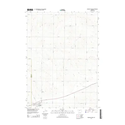
2014 Map of Randolph North
USGS Topo · Published 2014About this map
Randolph anchors the southwestern corner of this survey, where the town's grid meets the agricultural expanse of northeastern Nebraska. The settlement is organized along central thoroughfares such as W Wayne St and E Mosher St, with N Bridge St serving as a key north-south connector. Just north of the town center, Saint Frances Cem provides a focal point for local genealogy and heritage research. The landscape is defined by the winding course of Middle Logan Creek, which meanders eastward through the countryside, crossing beneath several section-line roads. This 2014 edition documents the highly regularized section-line grid system, where avenues like 560th Ave and roads like 870th Rd delineate the vast farming tracts of the region. The boundary between Pierce County and Cedar County is clearly visible, marking the administrative divisions that have shaped local land ownership for generations.
Find a feature on this map
28 named features on this map. Tap any name to fly to it.
Don’t see what you’re looking for? This feature index may not catch every label — zoom into the map to look around manually.
Map Details
Editions of this 2014 Randolph North Map
This is the sole edition of this map. No revisions or reprints were ever made.
Other maps of this area

1955 · Sioux City
USGS Topo · 1:250,000

1958 · Sioux City
USGS Topo · 1:250,000

1959 · Sioux City
USGS Topo · 1:250,000

1968 · Coleridge
USGS Topo · 1:24,000

1968 · Hartington
USGS Topo · 1:24,000

1968 · Hartington SW
USGS Topo · 1:24,000

1971 · Belden
USGS Topo · 1:24,000

1971 · Randolph South
USGS Topo · 1:24,000

1971 · Randolph North
USGS Topo · 1:24,000
1971 · Randolph SW
USGS Topo · 1:24,000