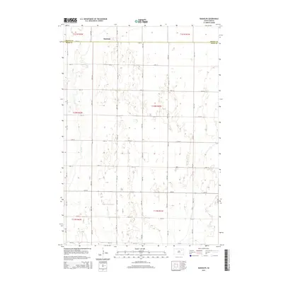
2015 Map of Randolph
USGS Topo · Published 2015About this map
The small settlement of Randolph sits at the northern edge of this James River Valley landscape, just south of the Brown Co Spink Co boundary. The area is defined by a complex network of glacial wetlands and depressions, with the intermittent course of Dry Run winding through the western sections of the township. A rigid grid of section-line roads, including 148th St and 399th Ave, partitions the prairie into productive agricultural tracts, reflecting the late 19th-century Public Land Survey System that shaped the Dakotas. This 2015 update of the landscape shows the enduring rural character of Spink County, where the placement of farmsteads and field boundaries remains heavily influenced by the drainage patterns of the seasonal Dry Run and numerous unnamed prairie potholes.
Find a feature on this map
25 named features on this map. Tap any name to fly to it.
Don’t see what you’re looking for? This feature index may not catch every label — zoom into the map to look around manually.
Map Details
Editions of this 2015 Randolph Map
This is the sole edition of this map. No revisions or reprints were ever made.
Other maps of this area

1894 · Conde
USGS Topo · 1:62,500

1895 · Aberdeen
USGS Topo · 1:125,000

1953 · Brentford
USGS Topo · 1:24,000

1953 · Stratford
USGS Topo · 1:24,000

1953 · Groton SW
USGS Topo · 1:24,000

1954 · Ferney
USGS Topo · 1:24,000

1954 · Aberdeen
USGS Topo · 1:250,000

1956 · Aberdeen
USGS Topo · 1:250,000
1958 · Randolph
USGS Topo · 1:24,000
1958 · Conde
USGS Topo · 1:24,000
Featured Places
- Tetonka Township, SD
- La Prairie Township, SD
- Garden Prairie Township, SD
- Randolph, SD
- East Rondell Township, SD