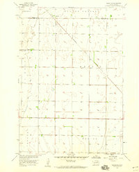
1958 Map of Randolph
USGS Topo · Published 1959About this map
Randolph sits at the northern edge of this James River Valley landscape, serving as a primary point of settlement along the border between Brown and Spink Counties. The region is defined by distinct prairie divisions such as Garden Prairie and La Prairie, where the flat topography is marked by a network of seasonal watercourses and depressions. The diagonal route of the Minneapolis and St Louis railroad cuts across the townships of Beotia and Benton, providing the essential transportation link for this agricultural area during the late 1950s.
Find a feature on this map
10 named features on this map. Tap any name to fly to it.
Don’t see what you’re looking for? This feature index may not catch every label — zoom into the map to look around manually.
Map Details
Editions of this 1958 Randolph Map
This is the sole edition of this map. No revisions or reprints were ever made.
Other maps of this area

1894 · Conde
USGS Topo · 1:62,500

1895 · Aberdeen
USGS Topo · 1:125,000

1953 · Brentford
USGS Topo · 1:24,000

1953 · Stratford
USGS Topo · 1:24,000

1953 · Groton SW
USGS Topo · 1:24,000

1954 · Ferney
USGS Topo · 1:24,000

1954 · Aberdeen
USGS Topo · 1:250,000

1956 · Aberdeen
USGS Topo · 1:250,000
1958 · Conde
USGS Topo · 1:24,000
1960 · Conde SW
USGS Topo · 1:24,000