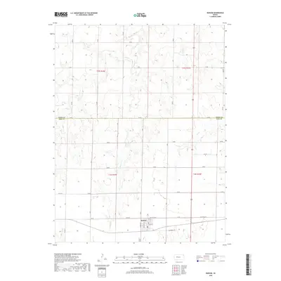
2018 Map of Ransom
USGS Topo · Published 2018About this map
Ransom serves as the primary population center in this western Kansas landscape, situated just south of the Trego County and Ness County line. The town's grid is clearly defined by local thoroughfares such as 1st St and Ogden St, while Old State Hwy 4 provides the east-west connection through the settlement. This 2018 survey illustrates a classic High Plains drainage pattern, where intermittent watercourses like Sand Creek, its East Branch, and Page Creek carve shallow valleys through the agricultural sections. To the southeast of the main town site, the Ransom Cemetery remains a significant landmark for those tracing local family histories in this rural region.
Find a feature on this map
21 named features on this map. Tap any name to fly to it.
Don’t see what you’re looking for? This feature index may not catch every label — zoom into the map to look around manually.
Map Details
Editions of this 2018 Ransom Map
This is the sole edition of this map. No revisions or reprints were ever made.
Other maps of this area

1893 · Ellis
USGS Topo · 1:125,000

1955 · Great Bend
USGS Topo · 1:250,000

1955 · Scott City
USGS Topo · 1:250,000

1957 · Great Bend
USGS Topo · 1:250,000

1958 · Great Bend
USGS Topo · 1:250,000

1958 · Scott City
USGS Topo · 1:250,000

1966 · Ransom SE
USGS Topo · 1:24,000
1966 · Ransom SW
USGS Topo · 1:24,000

1966 · Utica SE
USGS Topo · 1:24,000
1974 · Gibson Creek
USGS Topo · 1:24,000