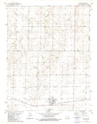
1980 Map of Ransom
USGS Topo · Published 1981About this map
Ransom serves as the primary hub of this High Plains landscape, situated along the Missouri Pacific railroad corridor at the southern edge of the sheet. The town's layout includes a central Park and a nearby Sewage Disposal Ponds facility, reflecting the infrastructure of a mid-century agricultural community. To the east of the town center, the Ransom Cem provides a focal point for local genealogical interest.
Find a feature on this map
20 named features on this map. Tap any name to fly to it.
Don’t see what you’re looking for? This feature index may not catch every label — zoom into the map to look around manually.
Map Details
Editions of this 1980 Ransom Map
This is the sole edition of this map. No revisions or reprints were ever made.
Other maps of this area

1893 · Ellis
USGS Topo · 1:125,000

1955 · Great Bend
USGS Topo · 1:250,000

1955 · Scott City
USGS Topo · 1:250,000

1957 · Great Bend
USGS Topo · 1:250,000

1958 · Great Bend
USGS Topo · 1:250,000

1958 · Scott City
USGS Topo · 1:250,000

1966 · Ransom SE
USGS Topo · 1:24,000
1966 · Ransom SW
USGS Topo · 1:24,000

1966 · Utica SE
USGS Topo · 1:24,000
1974 · Gibson Creek
USGS Topo · 1:24,000