
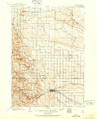
1898 Map of Rapid
USGS Topo · Published 1898About this map
The Fort Meade Military Reservation and the burgeoning hub of Rapid City anchor this late-19th-century survey of the Black Hills foothills. The landscape is a complex intersection of military presence, early ranching, and the arrival of industrial transport via the Chicago and Northwestern and the Chicago Milwaukee and St. Paul railroads. Settled points like Pactola and Nemo are established near the rugged canyons of Rapid Creek, while the U. S. Indian School sits just outside the Rapid City limits, reflecting the era's institutional footprint. Notable landmarks include the distinctive Bear Butte to the north and the localized industry suggested by Crystal Cave. Small outposts such as Don Dees Ranch and Morris illustrate the dispersed nature of habitation before more modern development altered the drainage patterns of Alkali Creek and Boxelder Creek.
Find a feature on this map
46 named features on this map. Tap any name to fly to it.
Don’t see what you’re looking for? This feature index may not catch every label — zoom into the map to look around manually.
Map Details
Editions of this 1898 Rapid Map
2 editions found
Other maps of this area

1893 · Rapid
USGS Topo · 1:125,000

1894 · Deadwood
USGS Topo · 1:125,000

1894 · Hermosa
USGS Topo · 1:125,000

1896 · Harney Peak
USGS Topo · 1:125,000

1899 · Sturgis
USGS Topo · 1:62,500

1901 · Hermosa
USGS Topo · 1:125,000

1901 · Harney Peak
USGS Topo · 1:125,000

1901 · Deadwood
USGS Topo · 1:125,000

1903 · Rapid
USGS Topo · 1:125,000

1905 · Saint Onge
USGS Topo · 1:62,500