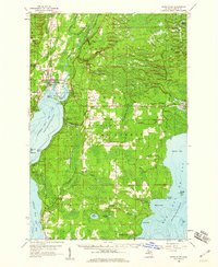
1958 Map of Rapid River
USGS Topo · Published 1960About this map
Hiawatha National Forest dominates this landscape where the Whitefish River and Tacoosh River empty into the northern reaches of Lake Michigan. The 1950s shoreline is defined by the sharp convergence of Little Bay de Noc and Big Bay de Noc, separated by a peninsula reaching down toward Stonington. This survey captures the region's mid-century character, balancing small-town life in Rapid River and Masonville with an economy shaped by the Minneapolis Sault Ste Marie and Atlantic RR and the logging legacy of the surrounding timberlands.
Find a feature on this map
72 named features on this map. Tap any name to fly to it.
Don’t see what you’re looking for? This feature index may not catch every label — zoom into the map to look around manually.
Map Details
Editions of this 1958 Rapid River Map
2 editions found
Other maps of this area

1932 · Gladstone NE
USGS Topo · 1:31,680

1932 · Rapid River NE
USGS Topo · 1:31,680

1932 · Trenary SW
USGS Topo · 1:31,680

1932 · Burnt Bluff NW
USGS Topo · 1:31,680

1932 · Garden NW and SW
USGS Topo · 1:31,680

1932 · Gladstone SE
USGS Topo · 1:31,680

1932 · Rapid River NW
USGS Topo · 1:31,680

1932 · Trenary SE
USGS Topo · 1:31,680

1932 · Rock SE
USGS Topo · 1:31,680

1932 · Rapid River SE
USGS Topo · 1:31,680