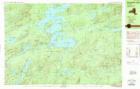
1989 Map of Raquette Lake
USGS Topo · Published 1989About this map
Raquette Lake dominates this 1980s landscape, serving as the central hub of a complex waterway network within the Adirondack Park. The map documents the intricate shoreline and surrounding highlands of Hamilton County, featuring notable landings and camps such as the Crags and Sagamore, reflecting the area's long-standing character as a premier summer retreat. The labyrinthine geography of South Bay, Boulder Bay, and numerous islands like Big Island and Osprey Island highlight a terrain defined by glacial activity and water travel.
Find a feature on this map
82 named features on this map. Tap any name to fly to it.
Don’t see what you’re looking for? This feature index may not catch every label — zoom into the map to look around manually.
Map Details
Editions of this 1989 Raquette Lake Map
2 editions found
Other maps of this area

1899 · Indian Lake
USGS Topo · 1:62,500

1900 · Canada Lake
USGS Topo · 1:62,500

1901 · Old Forge
USGS Topo · 1:62,500

1902 · Indian Lake
USGS Topo · 1:62,500

1903 · Big Moose
USGS Topo · 1:62,500

1903 · West Canada Lakes
USGS Topo · 1:62,500

1903 · Raquette Lake
USGS Topo · 1:62,500

1903 · Blue Mountain
USGS Topo · 1:62,500

1950 · Utica
USGS Topo · 1:250,000

1954 · Old Forge
USGS Topo · 1:62,500