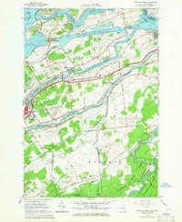
1964 Map of Raquette River
USGS Topo · Published 1966About this map
The Wiley Dondero Canal and the massive infrastructure of the Eisenhower Lock dominate the northern landscape of this mid-1960s survey, marking a transformative era for the St Lawrence River valley. This mapping highlights the international border shared with Cornwall Island, Ontario, while documenting the local expansion of Massena and Massena Center. The convergence of the Grass River, Raquette River, and St Regis River creates a complex hydrological network that historically fueled the region's industry and settlement patterns.
Find a feature on this map
40 named features on this map. Tap any name to fly to it.
Don’t see what you’re looking for? This feature index may not catch every label — zoom into the map to look around manually.
Map Details
Editions of this 1964 Raquette River Map
2 editions found
Other maps of this area

1906 · Massena
USGS Topo · 1:62,500

1907 · Massena
USGS Topo · 1:62,500

1915 · Moira
USGS Topo · 1:62,500

1917 · Moira
USGS Topo · 1:62,500

1942 · Norfolk
USGS Topo · 1:24,000

1942 · Barnhart Island
USGS Topo · 1:24,000

1942 · Massena
USGS Topo · 1:24,000

1943 · Barnhart Island
USGS Topo · 1:31,680
1943 · Massena
USGS Topo · 1:31,680
1943 · Norfolk
USGS Topo · 1:31,680