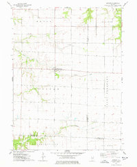
1974 Map of Raritan
USGS Topo · Published 1978About this map
Raritan serves as the central hub of this agricultural landscape, situated at the crossroads of a region where the drainage systems of Honey Creek and Ellison Creek have carved distinct patterns into the Illinois prairie. The topography reveals a transition from the level uplands of Point Pleasant and Sciota to the more dissected terrain surrounding the La Moine River in the south. This 1970s survey captures the rural layout of the time, highlighting community landmarks such as St Patricks Ch north of the main settlement. The map clearly delineates the complex administrative boundaries where Henderson, Warren, and McDonough counties meet, providing a clear record of land division across townships like Media and Blandinsville during this era of mid-century farming.
Find a feature on this map
14 named features on this map. Tap any name to fly to it.
Don’t see what you’re looking for? This feature index may not catch every label — zoom into the map to look around manually.
Map Details
Editions of this 1974 Raritan Map
This is the sole edition of this map. No revisions or reprints were ever made.
Other maps of this area

1916 · Good Hope
USGS Topo · 1:62,500

1918 · La Harpe
USGS Topo · 1:62,500

1918 · Good Hope
USGS Topo · 1:62,500

1921 · Monmouth
USGS Topo · 1:62,500

1923 · Monmouth
USGS Topo · 1:62,500

1934 · Oquawka
USGS Topo · 1:48,000

1940 · Oquawka
USGS Topo · 1:62,500

1958 · Burlington
USGS Topo · 1:250,000

1961 · Burlington
USGS Topo · 1:250,000

1963 · Burlington
USGS Topo · 1:250,000