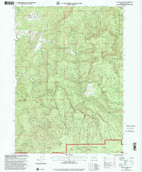
1998 Map of Rasler Creek
USGS Topo · Published 2001About this map
Siskiyou National Forest encompasses the majority of this landscape, dominated by the prominent elevation of Eden Ridge in the southern portion of the quadrangle. The terrain is defined by a dense network of drainage systems, with Rasler Creek and Rock Creek carving through the steep topography. In the northwest, Jenkins Prairie offers a rare break in the timbered slopes, providing a distinct landmark for those studying historical land use and early forest management in the Oregon Coast Range.
Find a feature on this map
13 named features on this map. Tap any name to fly to it.
Don’t see what you’re looking for? This feature index may not catch every label — zoom into the map to look around manually.
Map Details
Editions of this 1998 Rasler Creek Map
This is the sole edition of this map. No revisions or reprints were ever made.
Other maps of this area

1896 · Coos Bay
USGS Topo · 1:125,000

1898 · Coos Bay
USGS Topo · 1:125,000

1899 · Port Orford
USGS Topo · 1:125,000

1900 · Coos Bay
USGS Topo · 1:125,000

1903 · Port Orford
USGS Topo · 1:125,000

1928 · Sitkum
USGS Topo · 1:125,000

1942 · Coquille
USGS Topo · 1:62,500

1945 · Coquille
USGS Topo · 1:62,500

1954 · Coos Bay
USGS Topo · 1:250,000

1954 · Bone Mountain
USGS Topo · 1:62,500