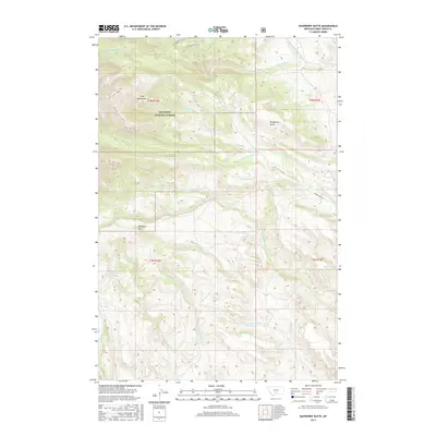
2017 Map of Raspberry Butte
USGS Topo · Published 2017About this map
The Gallatin National Forest encompasses the high-altitude terrain of the Crazy Mountains in this modern survey of Sweet Grass County. The landscape is defined by its complex drainage network, where the S Fork Big Timber Cr and Middle Fork Big Timber Cr carve through the northern reaches. Prominent peaks including Raspberry Butte and Kid Royal Mtn anchor the central topography, while the Beley Lakes sit in a high basin near the headwaters of Swamp Cr. Human access is primarily indicated by the solitary Swamp Creek Rd traversing the eastern slopes. This map provides a detailed look at the watershed boundaries between numerous creeks, such as Sawmill Cr, Butler Cr, and the W Fork Little Timber Cr, as they descend from the mountain front toward the valleys below.
Find a feature on this map
22 named features on this map. Tap any name to fly to it.
Don’t see what you’re looking for? This feature index may not catch every label — zoom into the map to look around manually.
Map Details
Editions of this 2017 Raspberry Butte Map
This is the sole edition of this map. No revisions or reprints were ever made.
Other maps of this area

1886 · Little Belt Mts.
USGS Topo · 1:250,000

1891 · Livingston
USGS Topo · 1:250,000

1893 · Livingston
USGS Topo · 1:250,000

1894 · Little Belt Mts.
USGS Topo · 1:250,000

1897 · Little Belt Mts.
USGS Topo · 1:250,000

1898 · Little Belt Mts.
USGS Topo · 1:250,000

1902 · Little Belt Mts.
USGS Topo · 1:250,000

1947 · Bozeman
USGS Topo · 1:250,000

1948 · Bozeman
USGS Topo · 1:250,000

1948 · White Sulphur Springs
USGS Topo · 1:250,000