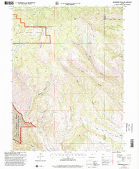
1998 Map of Raspberry Knoll
USGS Topo · Published 2002About this map
Uinta National Forest lands dominate this high-altitude landscape along the border of Wasatch and Duchesne counties, centered on the prominent Raspberry Knoll. The 1998 revision of this terrain captures the complex drainages of the western Uintah Mountains, where water sources like Little Red Spring and various unnamed Spring points feed a network of narrow canyons. Significant topographic features such as Bobby Duke Pass and Bobby Duke Ridge define the northern sector, while the southwestern corner is protected by the Deep Creek State Wildlife Management Area. A few industrial markers, including an Oil Well and a Mine, suggest the presence of resource extraction amidst the hollows. The rugged transit through The Narrows and along Little Currant Creek highlights the primitive road network used by foresters and hunters at the end of the twentieth century.
Find a feature on this map
24 named features on this map. Tap any name to fly to it.
Don’t see what you’re looking for? This feature index may not catch every label — zoom into the map to look around manually.
Map Details
Editions of this 1998 Raspberry Knoll Map
2 editions found
Other maps of this area

1885 · Salt Lake
USGS Topo · 1:250,000

1885 · Uinta
USGS Topo · 1:250,000

1907 · Strawberry Valley
USGS Topo · 1:125,000

1909 · Strawberry Valley
USGS Topo · 1:125,000

1954 · Salt Lake City
USGS Topo · 1:250,000

1958 · Salt Lake City
USGS Topo · 1:250,000

1960 · Salt Lake City
USGS Topo · 1:250,000

1962 · Deep Creek Canyon
USGS Topo · 1:24,000
1962 · Wolf Creek
USGS Topo · 1:24,000

1962 · Fruitland
USGS Topo · 1:24,000