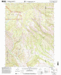
1998 Map of Raspberry Knoll
USGS Topo · Published 2002About this map
Raspberry Knoll stands as a central landmark in this high-elevation landscape within the Uinta National Forest, where the topography is defined by complex drainages and ridgelines. The transition between the Heber Ranger District and the neighboring Duchesne County line is marked by high-country features such as Bobby Duke Pass and Bobby Duke Ridge. The presence of a Mine and an Oil Well indicates the intersection of resource extraction with public lands, while the Deep Creek State Wildlife Management Area designates protected habitat to the south. Water is a critical element of this environment, with names like Little Red Spring, Little Currant Creek, and a network of drainages including Wagon Boss Canyon and Ringwood Hollow providing a map of seasonal and perennial flows in an otherwise arid high-desert forest system.
Find a feature on this map
23 named features on this map. Tap any name to fly to it.
Don’t see what you’re looking for? This feature index may not catch every label — zoom into the map to look around manually.
Map Details
Editions of this 1998 Raspberry Knoll Map
2 editions found
Other maps of this area

1885 · Salt Lake
USGS Topo · 1:250,000

1885 · Uinta
USGS Topo · 1:250,000

1907 · Strawberry Valley
USGS Topo · 1:125,000

1909 · Strawberry Valley
USGS Topo · 1:125,000

1954 · Salt Lake City
USGS Topo · 1:250,000

1958 · Salt Lake City
USGS Topo · 1:250,000

1960 · Salt Lake City
USGS Topo · 1:250,000

1962 · Deep Creek Canyon
USGS Topo · 1:24,000
1962 · Wolf Creek
USGS Topo · 1:24,000

1962 · Fruitland
USGS Topo · 1:24,000