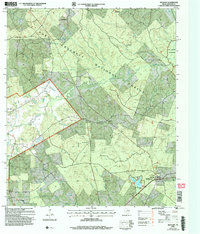
2004 Map of Ratcliff
USGS Topo · Published 2006About this map
The Davy Crockett National Forest dominates this East Texas landscape, providing a view of Houston County's timberlands as they appeared during the mid-2000s update. The map highlights the localized settlement patterns of Tadmor, Ratcliff, and Burrantown, which are deeply intertwined with the region's forestry and recreational history. Along the banks of Hickory Creek and Cochino Bayou, several pioneer-era sites are preserved, including the Bethel Cem, Old Zion Cem, and Conner Cem. The southeast corner is anchored by Ratcliff Lake, which serves as a recreational hub with its hunt camp and the Ratcliff Work Ctr. To the northeast, the Big Slough Wilderness remains an undeveloped pocket of bottomland hardwoods, showcasing the primary drainage of Big Slough and its network of secondary creeks like Walnut Creek.
Find a feature on this map
40 named features on this map. Tap any name to fly to it.
Don’t see what you’re looking for? This feature index may not catch every label — zoom into the map to look around manually.
Map Details
Editions of this 2004 Ratcliff Map
This is the sole edition of this map. No revisions or reprints were ever made.
Other maps of this area

1946 · Alto
USGS Topo · 1:62,500

1950 · Crockett NE
USGS Topo · 1:24,000

1950 · Kennard NE
USGS Topo · 1:24,000

1950 · Ratcliff
USGS Topo · 1:24,000

1950 · Centralia
USGS Topo · 1:24,000

1951 · Kennard
USGS Topo · 1:24,000

1951 · Centralia
USGS Topo · 1:24,000

1951 · Berea
USGS Topo · 1:24,000

1951 · Crockett NE
USGS Topo · 1:24,000

1951 · Kennard NE
USGS Topo · 1:24,000