
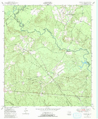
1950 Map of Kennard NE
USGS Topo · Published 1973About this map
The Neches River winds through the heart of the East Texas piney woods in this mid-century survey, defining the boundaries of Crockett National Forest and the county lines for Houston, Cherokee, and Angelina. The landscape is deeply tied to the timber industry of the era, marked by an extensive Logging Railroad network and an Old Railroad Grade that cut through the dense forest. Small rural communities are anchored by landmarks like Sweet Union Ch, Mount Vernon Ch, and the Wells Sch. Along the riverbanks, topographic details reveal the prominence of Shooks Bluff and its namesake Shooks Bluff Cem, providing valuable location data for genealogists. Waterways such as Larrison Creek and Sandy Creek feed into the Neches, while the presence of the Malibu Club suggests the recreational use of the region's natural resources.
Find a feature on this map
30 named features on this map. Tap any name to fly to it.
Don’t see what you’re looking for? This feature index may not catch every label — zoom into the map to look around manually.
Map Details
Editions of this 1950 Kennard NE Map
2 editions found
Other maps of this area

1946 · Alto
USGS Topo · 1:62,500

1950 · Ratcliff
USGS Topo · 1:24,000

1950 · Centralia
USGS Topo · 1:24,000

1951 · Kennard
USGS Topo · 1:24,000

1951 · Wells
USGS Topo · 1:24,000

1951 · Wells SW
USGS Topo · 1:24,000

1951 · Centralia
USGS Topo · 1:24,000

1951 · Kennard NE
USGS Topo · 1:24,000

1951 · Ratcliff
USGS Topo · 1:24,000

1952 · Douglass
USGS Topo · 1:62,500