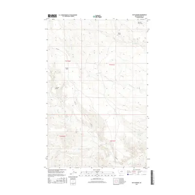
2017 Map of Rattlesnake
USGS Topo · Published 2017About this map
Cromley Bench overlooks a landscape defined by an intricate network of drainage channels in this Blaine County region. The topography is dominated by numerous coulees, such as Tin Cup Coulee and Coal Mine Coulee, which carve through the terrain and feed into local water systems like Rattlesnake Cr and Cow Cr. This drainage pattern suggests a landscape shaped by intermittent water flow, where deep ravines provide the primary relief in an otherwise high-plains environment.
Find a feature on this map
16 named features on this map. Tap any name to fly to it.
Don’t see what you’re looking for? This feature index may not catch every label — zoom into the map to look around manually.
Map Details
Editions of this 2017 Rattlesnake Map
This is the sole edition of this map. No revisions or reprints were ever made.
Other maps of this area

1943 · Landusky
USGS Topo · 1:125,000

1953 · Havre
USGS Topo · 1:250,000

1954 · Lewistown
USGS Topo · 1:250,000

1956 · Rattlesnake
USGS Topo · 1:62,500

1957 · Havre
USGS Topo · 1:250,000

1958 · Havre
USGS Topo · 1:250,000

1959 · Lewistown
USGS Topo · 1:250,000

1971 · Putnam Lake
USGS Topo · 1:24,000
1971 · Lake Seventeen West
USGS Topo · 1:24,000
1971 · John Coulee
USGS Topo · 1:24,000