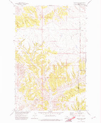
1971 Map of John Coulee
USGS Topo · Published 1974About this map
Fort Belknap Indian Reservation Boundary marks the eastern edge of this Missouri River Basin landscape, where the high plains break into a network of complex drainage systems. The terrain is characterized by the Badlands and deep-set coulees, including John Coulee and Buck Coulee, which serve as the primary topographical markers for this region of Blaine and Phillips counties. This 1971 field-checked survey reveals a land defined more by its natural geography and watercourses like Little Suction Creek than by human infrastructure. A few utilitarian traces appear across the drainage divides, such as a Jeep Trail and a noted Drill Hole, reflecting the area's use for resource exploration and cattle ranging during the early 1970s.
Find a feature on this map
12 named features on this map. Tap any name to fly to it.
Don’t see what you’re looking for? This feature index may not catch every label — zoom into the map to look around manually.
Map Details
Editions of this 1971 John Coulee Map
This is the sole edition of this map. No revisions or reprints were ever made.
Other maps of this area

1943 · Landusky
USGS Topo · 1:125,000

1953 · Havre
USGS Topo · 1:250,000

1954 · Cow Island
USGS Topo · 1:24,000

1954 · Sturgeon Island
USGS Topo · 1:24,000

1954 · Lewistown
USGS Topo · 1:250,000

1956 · Rattlesnake
USGS Topo · 1:62,500

1957 · Havre
USGS Topo · 1:250,000

1958 · Havre
USGS Topo · 1:250,000

1959 · Lewistown
USGS Topo · 1:250,000

1971 · Crazyman Coulee
USGS Topo · 1:24,000