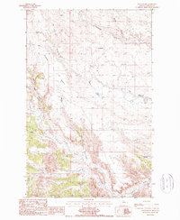
1987 Map of Rattlesnake
USGS Topo · Published 1987About this map
Cromley Bench and Putnam Bench define the high, flat plateaus of this Blaine County landscape, where the land falls away into a complex system of drainage coulees. This 1987 provisional survey shows a remote area primarily shaped by natural waterways like Rattlesnake Creek and Tin Cup Coulee, which cut deep impressions into the prairie. Evidence of small-scale resource extraction and infrastructure appears in the form of a Coal Mine tucked into a western coulee and a Pipeline traversing the southern sections.
Find a feature on this map
13 named features on this map. Tap any name to fly to it.
Don’t see what you’re looking for? This feature index may not catch every label — zoom into the map to look around manually.
Map Details
Editions of this 1987 Rattlesnake Map
This is the sole edition of this map. No revisions or reprints were ever made.
Other maps of this area

1943 · Landusky
USGS Topo · 1:125,000

1953 · Havre
USGS Topo · 1:250,000

1954 · Lewistown
USGS Topo · 1:250,000

1956 · Rattlesnake
USGS Topo · 1:62,500

1957 · Havre
USGS Topo · 1:250,000

1958 · Havre
USGS Topo · 1:250,000

1959 · Lewistown
USGS Topo · 1:250,000

1971 · Putnam Lake
USGS Topo · 1:24,000
1971 · Lake Seventeen West
USGS Topo · 1:24,000
1971 · John Coulee
USGS Topo · 1:24,000