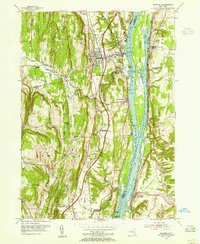
1953 Map of Ravena
USGS Topo · Published 1955About this map
The Hudson River dominates this mid-century landscape, serving as a corridor for commerce and transport between the hills of Coeymans and Schodack. Numerous river islands like Houghtaling Island and Schodack Island fragment the water, while the New York Central railroad and the emerging New York State Thruway trace parallel routes on opposite banks. This era marks a significant transition in regional mobility as high-speed road infrastructure began to bypass older river towns like Ravena and New Baltimore.
Find a feature on this map
62 named features on this map. Tap any name to fly to it.
Don’t see what you’re looking for? This feature index may not catch every label — zoom into the map to look around manually.
Map Details
Editions of this 1953 Ravena Map
3 editions found
Other maps of this area

1893 · Troy
USGS Topo · 1:62,500

1893 · Coxsackie
USGS Topo · 1:62,500

1893 · Albany
USGS Topo · 1:62,500

1894 · Coxsackie
USGS Topo · 1:62,500

1895 · Troy
USGS Topo · 1:62,500

1895 · Albany
USGS Topo · 1:62,500

1898 · Albany
USGS Topo · 1:62,500

1898 · Troy
USGS Topo · 1:62,500

1903 · Kinderhook
USGS Topo · 1:62,500

1925 · Troy
USGS Topo · 1:48,000