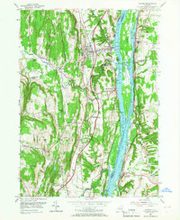
1953 Map of Ravena
USGS Topo · Published 1966About this map
Hudson River commerce and transportation dominate this 1950s landscape, where the New York Central railroad runs parallel to the water's edge and the then-new New York State Thruway cuts through the western uplands. This survey documents the river towns of Coeymans, Ravena, and New Baltimore at a moment of significant infrastructure expansion. Genealogists will find notable detail in the small family and local burial grounds like Waldron Cem, Lish Homestead Cem, and Firwood Cem. The geography is defined by a series of significant river islands including Houghtaling Island and Schodack Island, while local industry and rural life are represented by features such as Deans Mill, the Aquetuck Sch, and the Coxsackie Lighthouse.
Find a feature on this map
43 named features on this map. Tap any name to fly to it.
Don’t see what you’re looking for? This feature index may not catch every label — zoom into the map to look around manually.
Map Details
Editions of this 1953 Ravena Map
3 editions found
Other maps of this area

1893 · Troy
USGS Topo · 1:62,500

1893 · Coxsackie
USGS Topo · 1:62,500

1893 · Albany
USGS Topo · 1:62,500

1894 · Coxsackie
USGS Topo · 1:62,500

1895 · Troy
USGS Topo · 1:62,500

1895 · Albany
USGS Topo · 1:62,500

1898 · Albany
USGS Topo · 1:62,500

1898 · Troy
USGS Topo · 1:62,500

1903 · Kinderhook
USGS Topo · 1:62,500

1925 · Troy
USGS Topo · 1:48,000