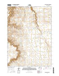
2017 Map of Rawhide Pocket
USGS Topo · Published 2017About this map
Rawhide Pocket defines this high-desert portion of Malheur County, where the intricate drainage system of the W Little Owyhee River carves through the volcanic landscape. The terrain is marked by significant topographical shifts, from the depths of Louse Canyon to the elevation of Toppin Creek Butte. A complex network of water management features reveals the region's ranching and land-use history, with numerous named catchments such as Harvey-Cracker Reservoir, Pack Rat Reservoir, and Section Sixteen Reservoir distributed across the range. Movement through this arid country is anchored by Sharon Creek Reservoir Rd, which provides access to landmarks like Bull Flat and the steep walls of Toppin Creek Canyon. The map illustrates a landscape where survival and commerce are dictated by seasonal water flows, as seen in the various creek systems including Little Spring Cr and Toppin Cr.
Find a feature on this map
25 named features on this map. Tap any name to fly to it.
Don’t see what you’re looking for? This feature index may not catch every label — zoom into the map to look around manually.
Map Details
Editions of this 2017 Rawhide Pocket Map
This is the sole edition of this map. No revisions or reprints were ever made.
Other maps of this area

1955 · Jordan Valley
USGS Topo · 1:250,000

1957 · Jordan Valley
USGS Topo · 1:250,000

1958 · Jordan Valley
USGS Topo · 1:250,000
1982 · Deacon Crossing
USGS Topo · 1:24,000
1982 · Rawhide Pocket
USGS Topo · 1:24,000
1982 · Defeat Butte
USGS Topo · 1:24,000

1982 · Guadalupe Meadows
USGS Topo · 1:24,000
1982 · Stoney Corral
USGS Topo · 1:24,000
1982 · Rawhide Springs
USGS Topo · 1:24,000
1982 · No Crossing Crossing
USGS Topo · 1:24,000