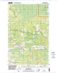
1999 Map of Ray
USGS Topo · Published 2003About this map
Koochiching State Forest dominates this northern landscape, where the intricate hydrology of the Rat Root River and its East Branch Rat Root River winds through dense woodlands and wetlands. The settlement of Ray serves as a central point of reference along the southern transit corridor, situated near the intersection of local logging and access routes. In the northeast, the map details the shoreline of Kabetogama Lake, marking the transition into the protected boundaries of Voyageurs National Park.
Find a feature on this map
12 named features on this map. Tap any name to fly to it.
Don’t see what you’re looking for? This feature index may not catch every label — zoom into the map to look around manually.
Map Details
Editions of this 1999 Ray Map
This is the sole edition of this map. No revisions or reprints were ever made.
Other maps of this area

1919 · International Falls
USGS Topo · 1:62,500

1954 · International Falls
USGS Topo · 1:250,000

1957 · International Falls
USGS Topo · 1:250,000

1958 · International Falls
USGS Topo · 1:250,000

1963 · Ranier
USGS Topo · 1:24,000

1969 · Ray SE
USGS Topo · 1:24,000

1969 · Island View
USGS Topo · 1:24,000

1969 · Ericsburg
USGS Topo · 1:24,000

1969 · Ericsburg SE
USGS Topo · 1:24,000

1969 · Ray
USGS Topo · 1:24,000