
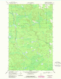
1969 Map of Ericsburg SE
USGS Topo · Published 1971About this map
Beaver Brook winds through this northern Koochiching County landscape, defining a terrain shaped by water and seasonal access. During the late 1960s, this area relied heavily on a network of Winter Trails, indicating a remote region where heavy transport or travel was likely restricted to the frozen months. A handful of Gravel Pits are scattered across the sheet, suggesting localized industry or road maintenance in this timber-rich environment. Occasional water sources like a Flowing Well and a Spring appear alongside Ester Brook, serving as critical landmarks in a territory otherwise dominated by marshes and woods. The mapping of fence and field lines via aerial photography reveals the subtle imprint of human activity on a landscape that remains largely undeveloped.
Find a feature on this map
7 named features on this map. Tap any name to fly to it.
Don’t see what you’re looking for? This feature index may not catch every label — zoom into the map to look around manually.
Map Details
Editions of this 1969 Ericsburg SE Map
2 editions found
Other maps of this area

1954 · International Falls
USGS Topo · 1:250,000

1957 · International Falls
USGS Topo · 1:250,000

1958 · International Falls
USGS Topo · 1:250,000

1969 · Ericsburg NW
USGS Topo · 1:24,000

1969 · Ericsburg
USGS Topo · 1:24,000

1969 · Ray
USGS Topo · 1:24,000

1969 · Ray SW
USGS Topo · 1:24,000

1969 · Ericsburg SW
USGS Topo · 1:24,000
1970 · Nett Lake River East
USGS Topo · 1:24,000
1970 · Nett Lake River West
USGS Topo · 1:24,000