
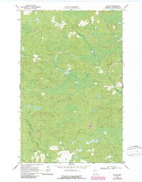
1969 Map of Ray SW
USGS Topo · Published 1971About this map
The Rat Root River meanders through this heavily forested portion of Koochiching County, showing the landscape as it appeared in the late 1960s. This survey, compiled from 1968 aerial photography and field-checked in 1969, highlights a remote region defined by its water systems and specialized transport routes. The Duluth Winnipeg and Pacific railroad cuts through the northeastern corner, providing a vital industrial link through the timberlands. Elsewhere, the absence of standard roads is notable; instead, a network of a Winter Trail segments suggests a seasonal economy where movement was dictated by the freezing of the marshy ground. Small-scale resource extraction is evident near several scattered Gravel Pits, while Bear Brook drains the southwestern terrain. This document is a clear record of northern Minnesota's wilderness character before modern development or expanded road networks reached these specific sections.
Find a feature on this map
6 named features on this map. Tap any name to fly to it.
Don’t see what you’re looking for? This feature index may not catch every label — zoom into the map to look around manually.
Map Details
Editions of this 1969 Ray SW Map
2 editions found
Other maps of this area

1954 · International Falls
USGS Topo · 1:250,000

1957 · International Falls
USGS Topo · 1:250,000

1958 · International Falls
USGS Topo · 1:250,000

1969 · Ray SE
USGS Topo · 1:24,000

1969 · Ericsburg
USGS Topo · 1:24,000

1969 · Ericsburg SE
USGS Topo · 1:24,000

1969 · Ray
USGS Topo · 1:24,000

1969 · Kabetogama
USGS Topo · 1:24,000

1969 · Nett Lake NE
USGS Topo · 1:24,000
1970 · Nett Lake River East
USGS Topo · 1:24,000