
1969 Map of Nett Lake NE
USGS Topo · Published 1971About this map
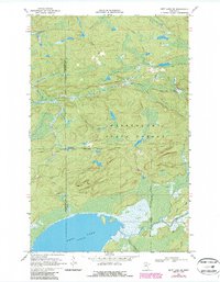
Nett Lake Indian Reservation and the Kabetogama State Forest define this northern Minnesota landscape, where the border between Koochiching and St. Louis counties cuts through dense woodland and swamp. The northern shore of Nett Lake dominates the southern edge of the map, fed by the winding Lost River and Portage Creek. This 1960s environment is characterized by a lack of permanent modern roads, relying instead on a network of Winter Trails that cross the terrain. A solitary Gravel Pit is the only indication of industrial activity in an area otherwise managed for timber and conservation. The mapping illustrates the complex shoreline and marshy transition zones essential to the local geography, showing how the Forest Boundary overlaps with tribal lands.
Find a feature on this map
9 named features on this map. Tap any name to fly to it.
Don’t see what you’re looking for? This feature index may not catch every label — zoom into the map to look around manually.
Map Details
Editions of this 1969 Nett Lake NE Map
2 editions found
Other maps of this area

1954 · International Falls
USGS Topo · 1:250,000

1957 · International Falls
USGS Topo · 1:250,000

1958 · International Falls
USGS Topo · 1:250,000

1968 · Ash Lake
USGS Topo · 1:24,000

1968 · Ash River SW
USGS Topo · 1:24,000

1968 · Orr SW
USGS Topo · 1:24,000

1969 · Ray SE
USGS Topo · 1:24,000

1969 · Nett Lake
USGS Topo · 1:24,000

1969 · Ray SW
USGS Topo · 1:24,000
1970 · Nett Lake SW
USGS Topo · 1:24,000