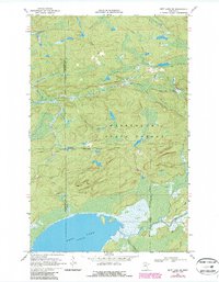
1969 Map of Nett Lake NE
USGS Topo · Published 1987About this map
Kabetogama State Forest dominates this northern Minnesota landscape, where the terrestrial environment is defined by dense woodland and a network of seasonal routes. The northern reaches of Nett Lake and the winding course of the Lost River anchor the drainage system, while the Nett Lake Indian Reservation Boundary marks a significant jurisdictional line through the forest. Evidence of industrial activity appears at a remote Gravel Pit, and various Winter Trails cross the terrain, illustrating the necessity of seasonal access in this boggy region. This 1960s survey, with updates from the early 1980s, reveals a land of significant elevation benchmarks such as Bm 1395 and Bm 1332, used to navigate the complex hydrology of Portage Creek.
Find a feature on this map
11 named features on this map. Tap any name to fly to it.
Don’t see what you’re looking for? This feature index may not catch every label — zoom into the map to look around manually.
Map Details
Editions of this 1969 Nett Lake NE Map
2 editions found
Other maps of this area

1954 · International Falls
USGS Topo · 1:250,000

1957 · International Falls
USGS Topo · 1:250,000

1958 · International Falls
USGS Topo · 1:250,000

1968 · Ash Lake
USGS Topo · 1:24,000

1968 · Ash River SW
USGS Topo · 1:24,000

1968 · Orr SW
USGS Topo · 1:24,000

1969 · Ray SE
USGS Topo · 1:24,000

1969 · Nett Lake
USGS Topo · 1:24,000

1969 · Ray SW
USGS Topo · 1:24,000

1969 · Nett Lake NE
USGS Topo · 1:24,000