
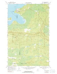
1969 Map of Nett Lake
USGS Topo · Published 1971About this map
Nett Lake serves as the focal point of this northern Minnesota landscape, where the settlement shares its name with the expansive water body to its west. The map documents a territory defined by seasonal accessibility and conservation, straddling the Koochiching Co St Louis Co line. Significant infrastructure includes the Nett Lake Ranger Station and a Radio Tower, while the Heritage Lookout Tower stands as a landmark of forestry oversight within the Kabetogama State Forest.
Find a feature on this map
18 named features on this map. Tap any name to fly to it.
Don’t see what you’re looking for? This feature index may not catch every label — zoom into the map to look around manually.
Map Details
Editions of this 1969 Nett Lake Map
2 editions found
Other maps of this area

1954 · Hibbing
USGS Topo · 1:250,000

1954 · International Falls
USGS Topo · 1:250,000

1957 · Hibbing
USGS Topo · 1:250,000

1957 · International Falls
USGS Topo · 1:250,000

1958 · International Falls
USGS Topo · 1:250,000

1958 · Hibbing
USGS Topo · 1:250,000

1964 · Hibbing
USGS Topo · 1:250,000

1964 · Gheen NW
USGS Topo · 1:24,000

1968 · Ash Lake
USGS Topo · 1:24,000

1968 · Orr SW
USGS Topo · 1:24,000