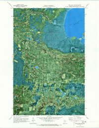
1970 Map of Nett Lake SW
USGS Topo · Published 1973About this map
Nett Lake Indian Reservation Boundary defines the northern reaches of this landscape, where the expanse of Nett Lake dominates the upper right quadrant. This 1970 orthophotomap provides a rare hybrid view of the Koochiching State Forest region, layering topographic contours over aerial photography to reveal the complex hydrology of the northern Minnesota wetlands. The Nett River snakes eastward from the lake's outlet, while the Little Fork River cuts through the western edge of the sheet. Unlike traditional line-drawn maps, this format clearly distinguishes the dense tree cover from the open water and marshlands. Several routes marked as Winter Trail cross the terrain, indicating the seasonal nature of movement through these woods, while Big Island stands as a prominent feature within the lake itself.
Find a feature on this map
9 named features on this map. Tap any name to fly to it.
Don’t see what you’re looking for? This feature index may not catch every label — zoom into the map to look around manually.
Map Details
Editions of this 1970 Nett Lake SW Map
This is the sole edition of this map. No revisions or reprints were ever made.
Other maps of this area

1954 · Hibbing
USGS Topo · 1:250,000

1954 · International Falls
USGS Topo · 1:250,000

1957 · Hibbing
USGS Topo · 1:250,000

1957 · International Falls
USGS Topo · 1:250,000

1958 · International Falls
USGS Topo · 1:250,000

1958 · Hibbing
USGS Topo · 1:250,000

1964 · Hibbing
USGS Topo · 1:250,000

1969 · Nett Lake
USGS Topo · 1:24,000

1969 · Nett Lake NE
USGS Topo · 1:24,000

1970 · Rauch
USGS Topo · 1:24,000