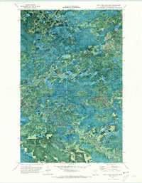
1970 Map of Nett Lake River East
USGS Topo · Published 1973About this map
Koochiching State Forest dominates this northern Minnesota landscape, where the meandering Nett River cuts across the center of the sheet. Published in the early 1970s using high-altitude photography from 1968 and 1969, the orthophotomap provides a rare visual of the dense woodland and wetlands that define this region. The Reservation Boundary and Forest Boundary intersect in the southern portion of the quadrangle, highlighting the administrative divisions of this remote territory. Navigability in this difficult terrain is marked by the presence of a Winter Trail and other unimproved routes. One of the few vertical landmarks is the Fort Lookout Tower, a classic feature of mid-century fire detection, while a small Gravel Pit indicates localized resource extraction within the heavy timber.
Find a feature on this map
9 named features on this map. Tap any name to fly to it.
Don’t see what you’re looking for? This feature index may not catch every label — zoom into the map to look around manually.
Map Details
Editions of this 1970 Nett Lake River East Map
This is the sole edition of this map. No revisions or reprints were ever made.
Other maps of this area

1954 · International Falls
USGS Topo · 1:250,000

1957 · International Falls
USGS Topo · 1:250,000

1958 · International Falls
USGS Topo · 1:250,000

1969 · Ericsburg SE
USGS Topo · 1:24,000

1969 · Ray SW
USGS Topo · 1:24,000

1969 · Ericsburg SW
USGS Topo · 1:24,000

1970 · Nett Lake River SE
USGS Topo · 1:24,000
1970 · Nett Lake SW
USGS Topo · 1:24,000
1970 · Nett Lake River West
USGS Topo · 1:24,000
1970 · Nett Lake NW
USGS Topo · 1:24,000