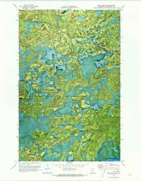
1970 Map of Nett Lake NW
USGS Topo · Published 1973About this map
Nett Lake Indian Reservation Boundary defines much of this northern Minnesota landscape, where the vast waters of Nett Lake meet a complex network of seasonal access routes. This orthophotomap, based on 1969 aerial photography, reveals the intricate relationship between the lake's irregular shoreline and the dense forest canopy. The presence of several Winter Trails and generic Trails underscores the reliance on frozen ground or specialized paths to navigate this remote terrain in the late 1960s. Aside from the scattered Gravel Pits, the land appears largely untouched by heavy industry, preserving a moment in time before more modern infrastructure altered the area's navigational patterns.
Find a feature on this map
6 named features on this map. Tap any name to fly to it.
Don’t see what you’re looking for? This feature index may not catch every label — zoom into the map to look around manually.
Map Details
Editions of this 1970 Nett Lake NW Map
This is the sole edition of this map. No revisions or reprints were ever made.
Other maps of this area

1954 · International Falls
USGS Topo · 1:250,000

1957 · International Falls
USGS Topo · 1:250,000

1958 · International Falls
USGS Topo · 1:250,000

1969 · Ray SE
USGS Topo · 1:24,000

1969 · Nett Lake
USGS Topo · 1:24,000

1969 · Ericsburg SE
USGS Topo · 1:24,000

1969 · Ray SW
USGS Topo · 1:24,000

1969 · Nett Lake NE
USGS Topo · 1:24,000

1970 · Nett Lake River SE
USGS Topo · 1:24,000
1970 · Nett Lake River East
USGS Topo · 1:24,000