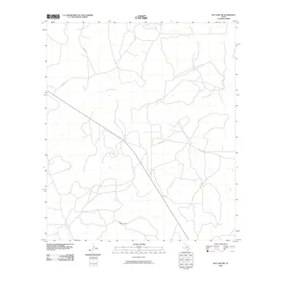
2010 Map of Ray Lake NW
USGS Topo · Published 2010About this map
South Llano River winds through the northern section of this Edwards County landscape, defining the local hydrology alongside the ephemeral pathway of Buffalo Draw. This 2010 survey illustrates a sparsely settled ranching region where the movement of people and livestock is dictated by a handful of established routes. Principal thoroughfares include Ranch Rd 2995 and Harrison Rd, which cut across the terrain to connect remote property holdings. The map reflects a modern era of land management in the Texas Hill Country, where traditional cattle and goat ranching operations are supported by a network of county roads like Co Rd 101. The intricate contour lines reveal the dissected plateau geography, where dry creek beds and draws provide the primary relief in an otherwise expansive and open landscape.
Find a feature on this map
5 named features on this map. Tap any name to fly to it.
Don’t see what you’re looking for? This feature index may not catch every label — zoom into the map to look around manually.
Map Details
Editions of this 2010 Ray Lake NW Map
This is the sole edition of this map. No revisions or reprints were ever made.
Other maps of this area

1893 · Rock Springs
USGS Topo · 1:125,000

1954 · Sonora
USGS Topo · 1:250,000

1958 · Sonora
USGS Topo · 1:250,000

1962 · Stewart Ranch
USGS Topo · 1:24,000

1963 · Harrison Ranch
USGS Topo · 1:24,000

1967 · Dunbar Draw SE
USGS Topo · 1:24,000

1970 · Ray Lake NW
USGS Topo · 1:24,000
1971 · Ray Lake SE
USGS Topo · 1:24,000
1971 · Ray Lake
USGS Topo · 1:24,000

1971 · Turney Draw SE
USGS Topo · 1:24,000