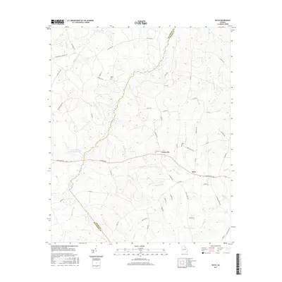
2017 Map of Rayle
USGS Topo · Published 2017About this map
The county boundary between Oglethorpe and Wilkes counties follows the meandering path of Dry Fork through a landscape defined by traditional Georgia agriculture and historical family landmarks. The small community of Rayle and nearby Centerville anchor the southern half of the map along Lexington Rd. Notable for genealogists, the terrain is dotted with ancestral sites such as Chafin Cem, Rock Cem, and Sardis Cem. Water remains a central feature of the local geography, from the University of Georgia Farm Lake to the headwaters of Kettle Cr and Beaverdam Cr. The presence of Clarks Mineral Spring indicates the area's natural hydrological features, while the dense network of local routes like Stevens Grove Church Rd and Sardis Church Rd suggests the enduring importance of community hubs and rural parishes.
Find a feature on this map
60 named features on this map. Tap any name to fly to it.
Don’t see what you’re looking for? This feature index may not catch every label — zoom into the map to look around manually.
Map Details
Editions of this 2017 Rayle Map
This is the sole edition of this map. No revisions or reprints were ever made.
Other maps of this area

1906 · Crawfordville
USGS Topo · 1:125,000

1953 · Athens
USGS Topo · 1:250,000

1958 · Athens
USGS Topo · 1:250,000

1959 · Athens
USGS Topo · 1:250,000

1963 · Athens
USGS Topo · 1:250,000

1965 · Woodville
USGS Topo · 1:24,000

1966 · Philomath
USGS Topo · 1:24,000
1970 · Jacksons Crossroads
USGS Topo · 1:24,000
1971 · Sandy Cross
USGS Topo · 1:24,000
1971 · Vesta
USGS Topo · 1:24,000