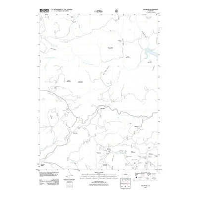
2011 Map of Raymond
USGS Topo · Published 2011About this map
Raymond and Riverside sit along the winding course of the Middle Saint Vrain Creek, serving as central points for a landscape defined by its deep mining legacy and mid-altitude terrain. The southeastern corner of this quadrangle is particularly dense with historical workings, where miners once sought fortune at sites like the Smuggler Mine, Fourth of July Mine, and the Alice Open Pit near Porphyry Mountain. These extraction sites are interwoven with local landmarks such as the Bunce School and Glacier View Camp, illustrating a mountain community where industry and civic life developed in tandem. To the north, the terrain transitions toward Button Rock Reservoir and the West Fork Little Thompson River, where the Big Elk Ranch and Big Elk Park mark the more open reaches of the foothills. This 2011 survey captures the spatial relationship between these established settlements and the complex network of mountain roads like St Vrain Rd and CO Hwy 87.
Find a feature on this map
73 named features on this map. Tap any name to fly to it.
Don’t see what you’re looking for? This feature index may not catch every label — zoom into the map to look around manually.
Map Details
Editions of this 2011 Raymond Map
This is the sole edition of this map. No revisions or reprints were ever made.
Other maps of this area

1902 · Boulder
USGS Topo · 1:62,500

1904 · Boulder
USGS Topo · 1:62,500

1905 · Mount Olympus
USGS Topo · 1:62,500

1907 · Mount Olympus
USGS Topo · 1:62,500

1915 · Longs Peak
USGS Topo · 1:125,000

1919 · Rocky Mountain National Park
USGS Topo · 1:125,000

1954 · Greeley
USGS Topo · 1:250,000

1957 · Greeley
USGS Topo · 1:250,000
1957 · Boulder
USGS Topo · 1:24,000

1957 · Allens Park
USGS Topo · 1:24,000