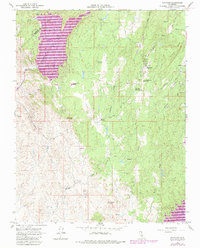
1962 Map of Raymond
USGS Topo · Published 1981About this map
Raymond and Knowles serve as the primary hubs in this part of Madera County, reflecting a landscape defined by granite quarrying and hard-rock mining operations. The presence of Raymond Granite Union H S and the Raymond Cemetery highlights the established community life that grew around these industries. To the south, mining history is evident in the cluster of shafts including the Rosa Shaft, North Shaft, and Jesse Belle Shaft, while the Buchanan Mine sits near the base of Iron Mtn.
Find a feature on this map
35 named features on this map. Tap any name to fly to it.
Don’t see what you’re looking for? This feature index may not catch every label — zoom into the map to look around manually.
Map Details
Editions of this 1962 Raymond Map
3 editions found
Other maps of this area

1912 · Mariposa
USGS Topo · 1:125,000

1919 · Indian Gulch
USGS Topo · 1:48,000

1919 · Raynor Creek
USGS Topo · 1:31,680

1919 · Little Table Mountain
USGS Topo · 1:31,680

1920 · Indian Gulch
USGS Topo · 1:62,500

1920 · Kismet
USGS Topo · 1:31,680

1921 · Daulton
USGS Topo · 1:31,680

1942 · Raymond
USGS Topo · 1:62,500

1942 · Daulton
USGS Topo · 1:24,000

1942 · Little Table Mountain
USGS Topo · 1:24,000