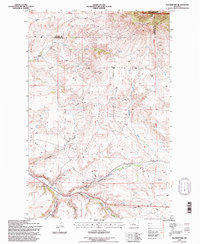
1995 Map of Raynesford
USGS Topo · Published 1997About this map
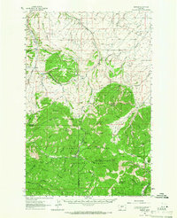
Raynesford occupies a narrow valley at the confluence of several drainages in the mid-1990s, where the Burlington Northern railroad corridor parallels the path of Big Otter Creek. The landscape transition is sharp here, moving from the open coulees like Government Coulee and Cache Coulee to the high elevations of the Highwood Mountains within the Lewis and Clark National Forest. The map documents a rugged interior geography defined by Rocky Ridge and deeply etched features like Kibbey Canyon. Beyond the small-town infrastructure of Raynesford, the area is marked by ranching and utility sites, including a Pumping Station and the Golladay electronics site. Numerous named water sources, such as Cora Creek and Williams Creek, flow through the terrain, illustrating the complex hydrology that supported early settlement on the border of Cascade and Judith Basin counties.
Find a feature on this map
29 named features on this map. Tap any name to fly to it.
Don’t see what you’re looking for? This feature index may not catch every label — zoom into the map to look around manually.
Map Details
Editions of this 1995 Raynesford Map
This is the sole edition of this map. No revisions or reprints were ever made.
Other maps of this area

1890 · Fort Benton
USGS Topo · 1:250,000

1892 · Fort Benton
USGS Topo · 1:250,000

1897 · Fort Benton
USGS Topo · 1:250,000

1954 · Great Falls
USGS Topo · 1:250,000
1956 · Belt
USGS Topo · 1:62,500

1957 · Great Falls
USGS Topo · 1:250,000
1961 · The Arch
USGS Topo · 1:24,000
1961 · Limestone Butte
USGS Topo · 1:24,000
1961 · Barker
USGS Topo · 1:62,500

1967 · Monarch NE
USGS Topo · 1:24,000