
1999 Map of Raynor Creek
USGS Topo · Published 2002About this map
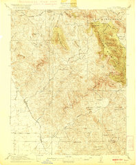
The Chowchilla River and its associated water management systems dominate this landscape at the intersection of Madera, Mariposa, and Merced counties. The Madera Canal cuts diagonally across the southwestern terrain, a testament to the region's complex hydraulic engineering designed to support valley agriculture. This transition from the flat agricultural plains of the San Joaquin Valley into the foothills is marked by Table Mtn and the winding course of Ash Slough, which diverges from the main river via a series of Diversion Dams.
Find a feature on this map
31 named features on this map. Tap any name to fly to it.
Don’t see what you’re looking for? This feature index may not catch every label — zoom into the map to look around manually.
Map Details
Editions of this 1999 Raynor Creek Map
This is the sole edition of this map. No revisions or reprints were ever made.
Other maps of this area

1912 · Mariposa
USGS Topo · 1:125,000

1915 · Owens Creek
USGS Topo · 1:31,680

1916 · Berenda
USGS Topo · 1:31,680

1918 · Owens Creek
USGS Topo · 1:31,680

1918 · Berenda
USGS Topo · 1:31,680

1918 · La Grand
USGS Topo · 1:31,680

1919 · Indian Gulch
USGS Topo · 1:48,000

1919 · Raynor Creek
USGS Topo · 1:31,680
1920 · Indian Gulch
USGS Topo · 1:62,500

1920 · Kismet
USGS Topo · 1:31,680