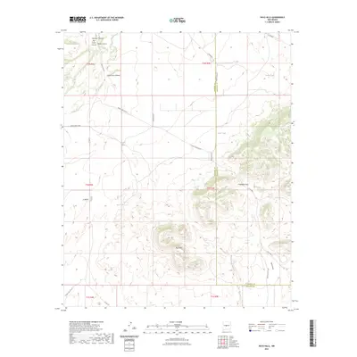
2023 Map of Rayo Hills
USGS Topo · Published 2023About this map
The Rayo Hills and the winding course of the Rancho Viejo Arroyo define this high-desert landscape along the boundary of Socorro and Torrance Counties. The terrain is marked by essential water sources for cattle and ranching, evidenced by scattered livestock reservoirs including Broome Tank, Bryan Tank, and Sais Tank. These features, along with the Red Tanks, suggest a long-standing reliance on seasonal water catchment in a region characterized by dramatic landforms like U-Butte and the Chupadera Gap.
Find a feature on this map
32 named features on this map. Tap any name to fly to it.
Don’t see what you’re looking for? This feature index may not catch every label — zoom into the map to look around manually.
Map Details
Editions of this 2023 Rayo Hills Map
This is the sole edition of this map. No revisions or reprints were ever made.
Other maps of this area

1916 · La Joya
USGS Topo · 1:125,000

1952 · Becker
USGS Topo · 1:24,000

1952 · Cerro Montoso
USGS Topo · 1:24,000

1954 · Socorro
USGS Topo · 1:250,000

1958 · Socorro
USGS Topo · 1:250,000

1962 · Socorro
USGS Topo · 1:250,000
1972 · Sierra Larga North
USGS Topo · 1:24,000
1972 · Chupadera Spring
USGS Topo · 1:24,000

1972 · Chupadera
USGS Topo · 1:24,000

1972 · Abo
USGS Topo · 1:24,000