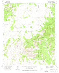
1972 Map of Rayo Hills
USGS Topo · Published 1975About this map
Rayo Hills and the surrounding high desert terrain dominate this early 1970s survey, illustrating a landscape defined by seasonal water management and topographical landmarks. The map tracks the border between Socorro and Torrance counties, cutting through a region where life centers on isolated water sources such as Brazil Windmill, Barber Tank, and the Rancho Viejo Well.
Find a feature on this map
20 named features on this map. Tap any name to fly to it.
Don’t see what you’re looking for? This feature index may not catch every label — zoom into the map to look around manually.
Map Details
Editions of this 1972 Rayo Hills Map
This is the sole edition of this map. No revisions or reprints were ever made.
Other maps of this area

1916 · La Joya
USGS Topo · 1:125,000

1952 · Becker
USGS Topo · 1:24,000

1952 · Cerro Montoso
USGS Topo · 1:24,000

1954 · Socorro
USGS Topo · 1:250,000

1958 · Socorro
USGS Topo · 1:250,000

1962 · Socorro
USGS Topo · 1:250,000
1972 · Sierra Larga North
USGS Topo · 1:24,000
1972 · Chupadera Spring
USGS Topo · 1:24,000

1972 · Chupadera
USGS Topo · 1:24,000

1972 · Abo
USGS Topo · 1:24,000