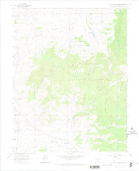
1962 Map of Razor Creek Dome
USGS Topo · Published 1974About this map
Razor Creek Dome dominates the high-altitude landscape of this 1960s-era survey on the border of Colorado-Saguache Co. Much of the terrain lies within the Gunnison National Forest, where a network of water-cut drainages including Prosser Creek and Wolverine Gulch define the geography. The presence of the Flying M Ranch and several interior parks like Mill Park and Sage Park suggests a land used primarily for ranching and seasonal grazing. Water management is evident at Vaughn Reservoir and its associated spillway, while the southern portion of the sheet is marked by the headwaters of West Pass Creek. Local landmarks like Prosser Rock, V Rock, and Green Mountain provide distinct navigational points in an area largely characterized by natural features and scattered gravel pits.
Find a feature on this map
30 named features on this map. Tap any name to fly to it.
Don’t see what you’re looking for? This feature index may not catch every label — zoom into the map to look around manually.
Map Details
Editions of this 1962 Razor Creek Dome Map
2 editions found
Other maps of this area

1956 · Montrose
USGS Topo · 1:250,000

1959 · Montrose
USGS Topo · 1:250,000

1960 · Montrose
USGS Topo · 1:250,000

1962 · Doyleville
USGS Topo · 1:24,000

1962 · West Baldy
USGS Topo · 1:24,000

1962 · Iris
USGS Topo · 1:24,000

1962 · Houston Gulch
USGS Topo · 1:24,000

1962 · Razor Creek Dome
USGS Topo · 1:24,000
1962 · Sawtooth Mountain
USGS Topo · 1:24,000
1965 · Cold Spring Park
USGS Topo · 1:24,000