
1962 Map of Reagan
USGS Topo · Published 1964About this map
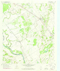
The Brazos River forms a serpentine southwestern boundary for this agricultural landscape, where the seasonal hydrology of Wild Horse Slough and Highbank Slough dictates the local geography. In the early 1960s, the rural community is anchored by the settlement of Reagan at the junction of the Southern Pacific railroad and several regional routes like Kosse Road. Smaller nodes like Highbank and Coymack align with the Missouri Pacific rail line, illustrating a settlement pattern deeply tied to transport corridors and the alluvial plains. Local genealogy is well-preserved through numerous family-linked sites, including Old Bowman Cem, Washington Cem, and Summers Cem, alongside rural congregations at Bowman Chapel and Fish Creek Ch. A series of Pipeline corridors and scattered Gravel Pits indicate the modern infrastructure then emerging alongside traditional river-bottom farming.
Find a feature on this map
41 named features on this map. Tap any name to fly to it.
Don’t see what you’re looking for? This feature index may not catch every label — zoom into the map to look around manually.
Map Details
Editions of this 1962 Reagan Map
2 editions found
Other maps of this area

1954 · Waco
USGS Topo · 1:250,000

1955 · Waco
USGS Topo · 1:250,000

1957 · McClanahan
USGS Topo · 1:24,000

1957 · Marlin
USGS Topo · 1:24,000

1961 · Baileyville
USGS Topo · 1:24,000

1962 · Rosebud
USGS Topo · 1:24,000

1962 · Hammond
USGS Topo · 1:24,000

1962 · Cedar Springs
USGS Topo · 1:24,000

1962 · Bremond
USGS Topo · 1:24,000

1965 · Kosse West
USGS Topo · 1:24,000