
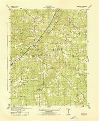
1944 Map of Reams
USGS Topo · Published 1944About this map
Rowanty Creek and its many tributaries, including Hatcher Run and Cattail Creek, define the drainage patterns of this rural landscape during the mid-1940s. The region is marked by a network of local congregations such as Gravelly Run Church and Little Zion Church, which served as community anchors alongside Reams School and Zion School. Transportation and industry were closely linked, with the Atlantic Coast Line railroad passing through the village of Reams and the community of Carson on the eastern edge. This survey, prepared under the direction of the Corps of Engineers, shows a landscape still heavily dependent on its watercourses and timber, evidenced by the presence of a Sawmill near Rowanta. The map documents the intricate boundary between Dinwiddie and Prince George counties, following the meandering path of the swampy bottomlands.
Find a feature on this map
30 named features on this map. Tap any name to fly to it.
Don’t see what you’re looking for? This feature index may not catch every label — zoom into the map to look around manually.
Map Details
Editions of this 1944 Reams Map
This is the sole edition of this map. No revisions or reprints were ever made.
Other maps of this area

1894 · Petersburg
USGS Topo · 1:62,500

1897 · Amelia
USGS Topo · 1:125,000

1919 · Jarratt
USGS Topo · 1:62,500

1919 · Mc Kenney
USGS Topo · 1:48,000

1921 · Mc Kenney
USGS Topo · 1:62,500

1943 · Mc Kenney
USGS Topo · 1:62,500

1943 · Dinwiddie
USGS Topo · 1:24,000

1943 · Sutherland
USGS Topo · 1:24,000

1943 · Richmond
USGS Topo · 1:250,000
1944 · Dinwiddie
USGS Topo · 1:31,680