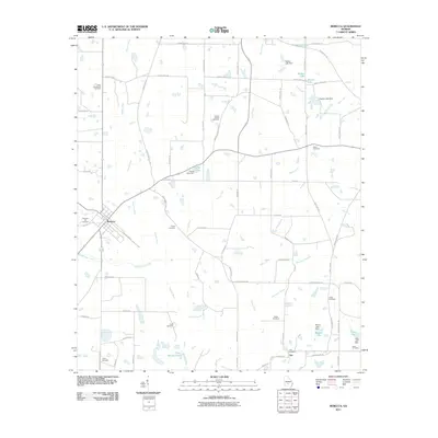
2011 Map of Rebecca
USGS Topo · Published 2011About this map
Rebecca and the small settlement of Arp anchor this South Georgia landscape during the early 21st century. The terrain is defined by the winding course of the Alapaha River and its numerous tributaries, including Double Run Creek and Young Creek. The map reveals a rural economy heavily dependent on water management, evidenced by a series of named reservoirs and dams such as Walker Lake, Young Lake, and Brown Lake. These water features, alongside larger bodies like Piney Woods Lake, highlight the region's agricultural irrigation and drainage patterns.
Find a feature on this map
77 named features on this map. Tap any name to fly to it.
Don’t see what you’re looking for? This feature index may not catch every label — zoom into the map to look around manually.
Map Details
Editions of this 2011 Rebecca Map
This is the sole edition of this map. No revisions or reprints were ever made.
Other maps of this area

1953 · Waycross
USGS Topo · 1:250,000

1958 · Waycross
USGS Topo · 1:250,000

1973 · Irwinville
USGS Topo · 1:24,000

1973 · Bethel
USGS Topo · 1:24,000

1973 · Fitzgerald West
USGS Topo · 1:24,000

1974 · Rebecca
USGS Topo · 1:24,000
1974 · Abbeville South
USGS Topo · 1:24,000
1974 · Pitts
USGS Topo · 1:24,000

1974 · Amboy
USGS Topo · 1:24,000
1977 · Rochelle
USGS Topo · 1:24,000